How to Use a Compass When Hiking (Without the Math Anxiety)
Affiliate Disclosure: I believe in honest, trail-tested gear reviews. When you purchase through links on my site, I may earn a small commission that helps keep Best Trail Backpacks running, at absolutely no extra cost to you. As an Amazon Associate, I earn from qualifying purchases.
There is something genuinely satisfying about switching your phone to airplane mode at the trailhead. No notifications, no signal, no distractions. Just you and the trail.
Then you remember the compass sitting at the bottom of your pack. You pull it out, look at the spinning needle and the ring of numbers, and suddenly feel less confident than you did thirty seconds ago.
Here is the honest truth: using a compass to navigate when hiking is mostly an exercise in lining up arrows. You do not need to do advanced geometry. You do not need to memorize degree conversions. You need to understand four parts of a simple tool and three short steps. That is genuinely it.
This guide walks you through how to use a compass when hiking, starting with what each part actually does and ending with you walking confidently toward a landmark you chose on purpose.
TL;DR: How to Use a Compass When Hiking
You do not need to be a math expert to navigate safely. By learning four basic parts of a baseplate compass and mastering the simple “red in the shed” technique, you can easily orient your map, take a bearing, and confidently navigate the trail without relying on your phone battery.
The Cheat Sheet: Compass Navigation at a Glance
Step
What You Do
Find North
The red magnetic needle always points to magnetic north. That is your starting point.
Orient Your Map
Turn your map so its north matches the compass’s north. Now the paper matches the real world.
Take a Bearing
Point the compass at a landmark, turn the dial to trap the red needle, and follow the direction arrow.
Follow It
Pick a visible target ahead of you, walk to it, then check your bearing again. Repeat.
Find North
What You Do: The red magnetic needle always points to magnetic north. That is your starting point.
Orient Your Map
What You Do: Turn your map so its north matches the compass’s north. Now the paper matches the real world.
Take a Bearing
What You Do: Point the compass at a landmark, turn the dial to trap the red needle, and follow the direction arrow.
Follow It
What You Do: Pick a visible target ahead of you, walk to it, then check your bearing again. Repeat.
If learning map-and-compass navigation feels a bit overwhelming to read about, taking a few minutes to watch this visual breakdown from REI can completely demystify the physical steps before you hit the trail.
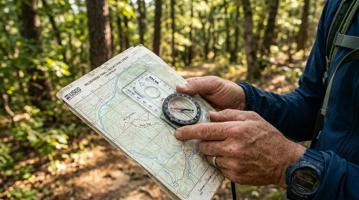
Anatomy of a Baseplate Compass in Plain English
Most beginner hikers stare at a compass and see a lot more going on than they need to. The millimeter rulers along the edges, the extra scales, and the tiny print around the dial can look incredibly confusing. You can ignore almost all of that today.
A baseplate compass looks complicated, but you only need to know four parts: the clear plastic base, the rotating dial (also called the housing), the magnetic needle that always points north, and the outline arrow inside the dial that helps you lock in your direction.
That last one is important enough to name. The printed arrow inside the dial is sometimes called the orienting arrow, or more memorably, “the shed.” You will see why that name matters in a moment.

Field Note: When you buy your first compass, spend five minutes just rotating the dial and watching the needle ignore it completely. The needle follows magnetism, not the dial. That click of understanding changes everything.
Trail Story: I remember standing on a trail in the Adirondacks, staring at my first compass, and feeling completely overwhelmed by the tiny numbers and scales. It was a massive relief when a passing ranger pointed out that I only needed to look at three things: the magnetic needle, the rotating housing, and the direction of travel arrow. Everything else was just noise for the type of hiking I was doing.
True North vs. Magnetic North: Why It Doesn’t Have to Be Scary
Maps are drawn with north pointing to true north, the geographic North Pole. Your compass points to magnetic north, a shifting point in northern Canada that is close but not exactly the same as true north.
The difference between the two is called declination. It sounds technical, but the practical reality is simple: you adjust your compass once before your hike to match your local map, and the math is done for the day.
Most good topographic maps (and the USGS maps used in North America) print the declination value right on the map. Many modern baseplate compasses have an adjustable declination correction built in. This means you twist a small screw to set it and forget it. If your compass does not have that feature, your local declination value can be easily found using the NOAA magnetic declination calculator online.
Field Note: Declination across most of the continental US and Canada ranges from 5 to 20 degrees. For casual day hikes on marked trails, the difference is small enough that many beginners skip the adjustment entirely without getting lost. For off-trail navigation or multi-day routes, take the two minutes to set it correctly.
Step 1: How to Orient Your Map So It Matches the Real World
Orienting a map sounds formal. What it actually means is turning the paper until the mountains on the map line up with the mountains in front of you.
Place your compass flat on your map. Turn your whole body, map, and compass together, until the red magnetic needle points to the top of the map. That is north on both the paper and in real life.
Now look up. The ridge on your left should be the ridge that appears on the left side of your map. The valley in front of you should match. If it does, you have oriented your map correctly, and your surroundings will start to make sense in a new way.
Field Note: Hold the map at waist or chest level while you orient it, not tilted toward your face. A flat compass gives you an accurate needle. A tilted one can give you a dragging needle that lies about where north actually is.
Step 2: How to Take a Bearing (Shooting a Direction)
Taking a bearing is just locking in a direction so you can follow it without looking at your compass every ten steps.
Point the front of your compass (the direction of travel arrow) at a landmark you want to walk toward. Hold the compass flat and level in front of you, at chest height, with the travel arrow pointing at your target.
This is the moment where holding it flat really matters. If you tilt the compass up toward your face to get a better look at the dial, the magnetic needle will drag or press against the plastic housing. That gives you a false reading. Keep it perfectly level, and bring your eyes down to it rather than lifting it up toward your eyes.
Now, keeping the compass pointed at your landmark, rotate the dial until the red magnetic needle sits perfectly inside the printed orienting arrow. This is the move people call “red in the shed.”
The needle is the red, and the shed is the outline arrow. When red is inside the shed, your bearing is locked.
Look at the number now sitting at the index line (the mark at the front of the baseplate). That is your bearing in degrees. You do not need to memorize it, but you can note it if you want.

Trail Story: Before I ever trusted myself with a compass in the backcountry, I spent an afternoon practicing the “red in the shed” technique at my local city park. I set bearings to park benches, oak trees, and water fountains. By the time I actually needed to use it on a real wilderness trail, the physical motion felt like second nature.
How to Follow a Bearing From Your Map to the Trail
Here is where compass navigation connects your paper map to your physical surroundings.
Place the edge of your compass baseplate on the map so it connects where you are standing to where you want to go. Rotate the dial until the lines inside the housing line up with the north-south grid lines on the map, with the orienting arrow pointing toward the map’s north.
Now pick up the compass and hold it flat in front of you. Turn your whole body until red is in the shed again. The direction-of-travel arrow now points toward your destination. Look up and pick the first landmark in that direction: a specific tree, a rocky outcrop, or a fork in the trail.
Walk to that landmark. When you arrive, repeat. You are navigating.
Field Note: When transferring a bearing from your map to the real world, rotate your body, not the compass dial. The dial is set. Your job is to turn until the needle agrees.
What to Do When You Lose Sight of Your Landmark
Trees, switchbacks, and terrain changes will occasionally swallow the landmark you were walking toward. This is not a crisis. It is just part of hiking navigation.
If you walk while staring down at your compass dial the whole time, you will drift off course almost immediately. The body compensates for small obstacles by veering, and without a visual reference, that drift adds up quickly.
Instead, use the compass to identify a specific target ahead, something you can actually see, and walk to it with your head up. When you reach it, check your compass and pick the next target. This technique is called “aiming off” by some navigators, and it keeps you moving accurately without turning every step into a navigation task.
If your landmark disappears behind a ridge, stop. Hold the compass flat, get red in the shed, and scan the horizon for the next thing that sits on that same line. A gap in the trees, a boulder, or a change in slope. Something will line up.
Trail Story: I learned the hard way that you cannot walk while staring down at your compass dial. On a heavily wooded trail a few years ago, I was so focused on keeping the needle perfectly aligned that I walked directly into a low-hanging branch and tripped over a root simultaneously. Pick your target tree, put the compass down, and walk with your head up.
The Myth: You Need GPS to Navigate Safely Outdoors
A common piece of advice in outdoor forums goes something like this: just use your phone’s GPS. It is more accurate, easier to read, and always right.
The first two points are fair. The third one is where it falls apart. A phone GPS is only “always right” when your phone is charged, your signal is working, and your app has the area downloaded offline. On a remote trail in questionable weather, that is a lot of conditions to depend on simultaneously.
A compass has no battery. It does not need a signal. It does not get a software update that breaks the interface two days before your trip. It weighs almost nothing.
Using a compass is not about rejecting technology. It is about not making your safety entirely dependent on it. Learning to use a compass and carrying one alongside your phone is the practical choice. It is also genuinely a satisfying skill to have.
Field Note: REI, the American Hiking Society, and most wilderness safety instructors recommend carrying a map and compass as core ten essentials, regardless of what technology you also bring. A phone GPS works beautifully until it does not.
The Simplest First Practice Hike
You do not need a remote trail to practice this. Pick a local park or open green space. Bring your compass and a printed map of the area, even a rough one from Google Maps works to start.
Orient the map to match your surroundings. Take a bearing toward something you can see, a bench, a tree, or a building corner. Practice getting red in the shed while holding the compass flat. Walk toward your landmark with your head up.
Do this five or six times in an hour, and compass navigation will stop feeling like a mystery. It will start feeling like a skill. A calm, confidence-building skill that will serve you on every trail after this one.
Next time you head to a local park, take your compass and practice orienting a map. If you have a question about declination or you tried this and something felt off, drop it in the comments below. There are no bad questions here, only ones worth asking before you are standing at a trailhead wondering which way to turn.
Related Reading: If you are just getting started with outdoor gear, be sure to check out our guide on Hiking Essentials for Beginners to see what else belongs in your pack before your first real trail day.
GEAR EXPERT & FOUNDER

Sonia Zannoni
With over two decades of experience testing outdoor gear, I cut through the marketing noise to bring you honest, trail-tested reviews. My goal is to help you pack smarter and hike with confidence.
About the Founder
Wow, there is so much I never knew about how to use a compass. I just thought that magnetic compasses always pointed north. It’s probably a good thing I haven’t gone on a long hike yet.
This post provides excellent information for anyone new to hiking like I am. Being that more people are starting to do more outdoor activities since the Covid-19 pandemic, I’m going to be passing on this information.
It just goes to show we can’t always rely on our smartphones.
Magnetic compasses always point North, but it’s the Magnetic North. If you don’t take into account the True North and apply the correction, which is the declination, then you won’t have an accurate bearing reading and most certainly be off-path or worst lost in the wilderness.
If you are new to hiking, here is a little piece of advice, don’t go hiking alone! Take a few minutes to read my post about finding a hiking partner, and don’t forget to pack a hiking compass and a map!
It seems some times that one has to go the through the unpleasant experience of getting lost to realize then that learning how to use a compass is an integral part of being a hiker.
I really appreciated learning how to obtain a bearing from a map. I’ll practice over the weekend how to take a bearing from the map as well as getting a bearing from the field and transfer it to a map. Thank you very much!
I am glad that you found value in my post on how to use a compass when hiking. Of course, getting lost on the trails is every hiker’s worst nightmare.