
What Are the Best Hikes in North America? 9 Trails and How to Get on Each One
You’ve booked time off for Zion, maybe the flight too, and then you read the fine print: the chains on Angels Landing, the part you came for, need a permit from an advance lottery. It’s an easy order to get backwards, booking the trip first and checking the trail second.
That isn’t carelessness. Most “best hikes” lists say nothing about permits, tickets or shuttles, and the parks change their systems every few years. Glacier ran vehicle reservations from 2021 to 2025, then moved Highline hikers to ticketed shuttle seats in 2026.
So what are the best hikes in North America if you want a great day hike or a first night out, not a month on a thru-hike? And which of them can you actually get on?
Here are nine trails across the US and Canada, each with what to book and when, the season window, the main hazard and, where the park names one, a shorter version. That way you can plan the trip around a hike you’ll really be able to do.
TL;DR: The Best Hikes in North America
- Check what to book before you book anything else: a lottery permit for the Angels Landing chains, a day-use ticket for Old Rag (March to November), a shuttle seat for the Highline, a shuttle reservation (or a very early start) for Lake Agnes and peak-season parking at Cape Breton’s Skyline. These systems change by year, so check the park’s page for yours.
- Compare distance and elevation gain, not the difficulty label. Each park rates its own trails, so “Moderate” in Banff and “Very Strenuous” in Shenandoah aren’t on one scale. The range runs from Cape Breton’s Skyline (6.5 km return, rated Easy) to Old Rag (9.4 miles, 2,348 feet of gain, a rock scramble).
- No permit, or not great with heights? The parks name shorter turnarounds: Scout Lookout at Zion, Cedar Ridge in the Grand Canyon, Alum Cave Bluffs in the Smokies and Myrtle Falls at Mount Rainier.
- The Grand Canyon needs no permit for a day hike, but the park says not to hike from the rim to the river and back in one day.
How I Chose These Nine Hikes (and Why the Thru-Hikes Aren’t Here)
These nine hikes passed five tests, and the multi-week thru-hikes were left out on purpose. Each one is a maintained trail you can do in a day or as a first overnight without climbing gear, with an official page that lists the distance and the access rules.
Most lists you’ll find put the Pacific Crest Trail next to a two-hour walk to a lake. One takes weeks and the other an afternoon, and neither entry tells you whether you can get a permit for the week you’re free. So I set the tests first:
- A trail, not an expedition. It’s maintained and works as a day hike or a first overnight with no climbing gear, because that’s the trip most people can take time off for.
- An official page behind every number. The park publishes the distance, the season and the access rules, so you can check them again for your own year.
- A range of difficulty. The list runs from an easy headland walk to a full-day scramble, with a shorter version where the park names one, so it isn’t only for very fit hikers.
- A spread across the continent. The US West, the US East, western Canada and eastern Canada, so most readers have at least one within reach.
- A real reason to plan a trip around it. These are the hikes people book time off for, not just a pleasant local loop.
A fair objection: lists like this are everywhere, and I haven’t hiked these trails. That’s why this list is built from each park’s own pages rather than my own trips. Every distance, season and booking rule comes from the NPS, Parks Canada or BC Parks.
I also counted getting onto the trail as part of what makes a hike worth choosing. A trail you can’t get a permit or a shuttle seat for isn’t one you can plan around, so the booking rules sit next to the distances in every section below.
I left out the thru-hikes, such as the Pacific Crest Trail, the Appalachian Trail and the John Muir Trail, because they take weeks rather than a trip’s worth of days. Routes framed around climbing are out for the same reason: they need gear and skills this list doesn’t assume.
Mexico is out for now, because this list only uses trails whose official pages publish the distance and the access rules. The Grand Canyon’s North Rim is out too, since the park says day hiking there is limited for the 2026 season, and the South Rim covers the canyon here.
Treat this as a starting point rather than the whole continent. There’s a lot more to cover region by region.
The Best Hikes in North America at a Glance
The nine hikes run from an easy headland walk in Cape Breton to a 9.4-mile rock scramble at Old Rag. Zion, Old Rag and Glacier need a permit, ticket or shuttle seat booked ahead, and Lake Agnes is easiest with a shuttle reservation.
Cape Breton’s Skyline needs a parking reservation in peak season, and Garibaldi a free pass on busy days. Narrow the list down by distance, gain and timing in the table.
Every figure in this table is the park’s own, so you can compare the nine side by side before you read their sections. If you only look at one column, make it What to Book, because that’s the one that decides your dates.
Trail and Park
Distance and Elevation
What to Book
When to Go
Main Hazard
Angels Landing (Zion, Utah)
5.4 mi round trip, 1,488 ft
Lottery permit for the chains past Scout Lookout
Seasonal and day-before lotteries
Narrow ridge, drop-offs up to 1,000 ft
South Kaibab to Ooh Aah Point or Cedar Ridge (Grand Canyon South Rim, Arizona)
1.8 mi round trip, 790 ft; or 3 mi round trip, 1,120 ft
Nothing for a day hike; trailhead by shuttle, foot or bike
Cedar Ridge is the summer limit; icy switchbacks in winter
No water, little shade, climb comes last
Highline Trail (Glacier, Montana)
7.6 mi one way to Granite Park Chalet, 800 ft gain
Logan Pass Shuttle seat (changes by year)
Logan Pass typically opens mid-June to early July
Exposed trail, fall risk
Skyline Trail (Mount Rainier, Washington)
5.5 mi round trip, 1,700 ft
No timed entry in 2026 (changes by year)
Wildflowers typically mid-July to August
Icy slope past Panorama Point
Old Rag Circuit (Shenandoah, Virginia)
9.4 mi, 2,348 ft
$2 day-use ticket, March 1 to November 30
Tickets release 30 and 5 days ahead
Rock scramble, often crowded
Alum Cave Trail (Great Smoky Mountains, Tennessee)
2.8, 4.6 or 10 mi round trip; gain not listed by the park
Parking tag for stays over 15 minutes
Ice and falling icicles in cold weather
Crowds, limited parking
Lake Agnes (Banff, Alberta)
3.4 km one way, 385 m gain
Parks Canada shuttle reservation, or a very early start
Avoid mid-October to mid-June (avalanche hazard)
Avalanche terrain outside mid-June to mid-October
Garibaldi Lake (Garibaldi Provincial Park, BC)
About 9 km one way, about 900 m
Free day-use vehicle pass on set days; camping reserved
Pass season June 12 to October 12, 2026; road not plowed in winter
Barrier zone, little cell coverage
Skyline Trail (Cape Breton Highlands, Nova Scotia)
6.5 km return or 8.2 km loop, 290 to 405 m elevation
Parking reservation in peak season (changes by year)
Reservations June 26 to October 25 in 2026; none November to May
Moose, cliff edges
Angels Landing (Zion, Utah)
Distance and Elevation: 5.4 mi round trip, 1,488 ft
What to Book: Lottery permit for the chains past Scout Lookout
When to Go: Seasonal and day-before lotteries
Main Hazard: Narrow ridge, drop-offs up to 1,000 ft
South Kaibab to Ooh Aah Point or Cedar Ridge (Grand Canyon South Rim, Arizona)
Distance and Elevation: 1.8 mi round trip, 790 ft; or 3 mi round trip, 1,120 ft
What to Book: Nothing for a day hike; trailhead by shuttle, foot or bike
When to Go: Cedar Ridge is the summer limit; icy switchbacks in winter
Main Hazard: No water, little shade, climb comes last
Highline Trail (Glacier, Montana)
Distance and Elevation: 7.6 mi one way to Granite Park Chalet, 800 ft gain
What to Book: Logan Pass Shuttle seat (changes by year)
When to Go: Logan Pass typically opens mid-June to early July
Main Hazard: Exposed trail, fall risk
Skyline Trail (Mount Rainier, Washington)
Distance and Elevation: 5.5 mi round trip, 1,700 ft
What to Book: No timed entry in 2026 (changes by year)
When to Go: Wildflowers typically mid-July to August
Main Hazard: Icy slope past Panorama Point
Old Rag Circuit (Shenandoah, Virginia)
Distance and Elevation: 9.4 mi, 2,348 ft
What to Book: $2 day-use ticket, March 1 to November 30
When to Go: Tickets release 30 and 5 days ahead
Main Hazard: Rock scramble, often crowded
Alum Cave Trail (Great Smoky Mountains, Tennessee)
Distance and Elevation: 2.8, 4.6 or 10 mi round trip; gain not listed by the park
What to Book: Parking tag for stays over 15 minutes
When to Go: Ice and falling icicles in cold weather
Main Hazard: Crowds, limited parking
Lake Agnes (Banff, Alberta)
Distance and Elevation: 3.4 km one way, 385 m gain
What to Book: Parks Canada shuttle reservation, or a very early start
When to Go: Avoid mid-October to mid-June (avalanche hazard)
Main Hazard: Avalanche terrain outside mid-June to mid-October
Garibaldi Lake (Garibaldi Provincial Park, BC)
Distance and Elevation: About 9 km one way, about 900 m
What to Book: Free day-use vehicle pass on set days; camping reserved
When to Go: Pass season June 12 to October 12, 2026; road not plowed in winter
Main Hazard: Barrier zone, little cell coverage
Skyline Trail (Cape Breton Highlands, Nova Scotia)
Distance and Elevation: 6.5 km return or 8.2 km loop, 290 to 405 m elevation
What to Book: Parking reservation in peak season (changes by year)
When to Go: Reservations June 26 to October 25 in 2026; none November to May
Main Hazard: Moose, cliff edges
Distances are as each park publishes them, so some are one way and some round trip. The US parks use miles and feet, the Canadian parks kilometers and meters. Anything marked as changing by year is worth checking on the park’s page for the year you go.
Pick the one or two that fit your fitness and timing, then read the booking line in their section before you book flights or time off.
Three Planning Myths That Can Cost You the Hike
Three assumptions catch a lot of people at the planning stage. Each one sounds reasonable, and each one is answered on the park’s own pages.
“Moderate” in One Park Isn’t “Moderate” in Another
Difficulty labels aren’t shared between parks. Parks Canada’s Moderate and the NPS’s Very Strenuous come from two different rating systems, so they can’t be lined up. To compare trails across parks, line up the distance and the elevation gain, not the word the park uses.
It’s easy to pick a trail because it says Moderate and your last Moderate hike felt fine. But each agency rates its own trails on its own scale: the NPS calls the Old Rag circuit Very Strenuous, while Parks Canada calls Lake Agnes Moderate and Cape Breton’s Skyline Easy.
Here’s how that looks in numbers. Lake Agnes is 3.4 km one way with 385 m of gain, about 1,260 feet over roughly 4.2 miles round trip. The Grand Canyon’s Cedar Ridge is 3 miles round trip with 1,120 feet, and Rainier’s Skyline 5.5 miles with 1,700 feet.
Those numbers tell you how much climbing each day holds, which no rating word can do across parks. Elevation gain is what your legs and lungs actually feel, so it tells you more about the day than any label.
A Permit Lottery Doesn’t Close the Whole Trail
At Zion, the lottery permit covers only the chains section past Scout Lookout. You can hike to Scout Lookout without one, about 2.25 miles and 1,000 feet of climbing from the Grotto. That’s roughly two-thirds of the climbing on the full hike.
If you don’t win the permit, it’s tempting to write off Angels Landing altogether. The permit covers the half-mile chains section beyond Scout Lookout, not the trail below it.
Most trails on this list have a turnaround the park names itself. So a missed lottery, or a ridge that looks worse in person than in photos, changes the plan rather than cancelling it.
No Permit Doesn’t Mean No Limit in the Grand Canyon
A Grand Canyon day hike needs no permit, but that isn’t permission to go far. The park’s day hiking page says not to hike rim to river and back in one day, especially May to September, and more than 300 people are rescued from the canyon each year.
The trap is the first hour. Going down feels easy, so carrying on a little further feels harmless.
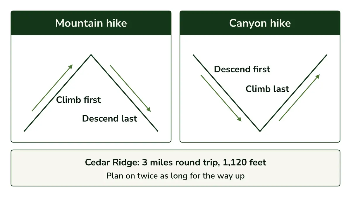
A canyon hike is a mountain hike turned upside down. The easy downhill comes first and the climb comes last, when you’re tired and the day is at its hottest, which is why the park tells you to plan on twice as long for the way up.
Six US Hikes and What It Takes to Get on Each
The six US hikes run from Zion in Utah to the Smokies in Tennessee, western parks first: Angels Landing in Zion, the South Kaibab Trail in the Grand Canyon, the Highline in Glacier, the Skyline Trail at Mount Rainier, Old Rag in Shenandoah and Alum Cave in the Smokies.
Three need something booked ahead. The Grand Canyon, Rainier and the Smokies don’t, though the Smokies need a parking tag.
Angels Landing, Zion: Scout Lookout Without a Permit, the Chains With One
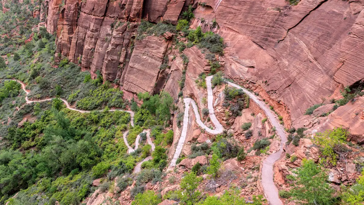
Angels Landing is 5.4 miles round trip, with a chains section on a narrow ridge where the drop-offs reach 1,000 feet. The chains need a lottery permit, and the climb to Scout Lookout doesn’t. If heights unsettle you, Scout Lookout is the honest turnaround.
- Distance and gain: 5.4 miles round trip with 1,488 feet of elevation, and most hikers take about 4 hours. It starts at the Grotto (Shuttle Stop 6), so treat it as a solid half day.
- Who it suits: hikers comfortable with steady climbing and with heights, because the final stretch is a narrow ridge where you hold chains.
- Who should skip it: anyone uneasy on exposed edges, and anyone hiking with a dog, since pets aren’t allowed. If you’re asking whether a fear of heights rules it out, the hazard line below is the one to weigh.
- What to book: a permit for the chains section through the permit lottery on Recreation.gov, either a seasonal lottery or the day-before lottery. It costs $6 to apply and $3 per person if you’re awarded one; check the park’s page for current fees.
- When to go: the lottery sets your date. In 2026 the seasonal lotteries opened February 13 for spring, April 1 for summer, July 1 for fall and October 1 for winter, and the day-before lottery closes at 3 p.m. Check the park’s page for your year.
- The main hazard: drop-offs of as much as 1,000 feet on each side, with parts of the trail less than three feet wide, so there’s very little room for a misstep.
- Shorter version: Scout Lookout, about 2.25 miles from the Grotto with 1,000 feet of climbing, and no permit needed.
I’d stop at Scout Lookout if you’re not sure how you’ll feel on the ridge. You’ll have done about two-thirds of the climbing by then, and turning back there still makes a full morning’s hike.
South Kaibab Trail, Grand Canyon: A Short Descent With the Climb Saved for Last
The South Kaibab Trail drops into the canyon from the South Rim. Ooh Aah Point is 1.8 miles round trip and Cedar Ridge is 3 miles, the park’s summer day-hike limit. There’s no water and little shade, and the park says to allow twice as long for the climb back.
- Distance and gain: Ooh Aah Point is 1.8 miles round trip with 790 feet of elevation change (1 to 2 hours), and Cedar Ridge 3 miles round trip with 1,120 feet (2 to 4 hours). Skeleton Point (6 miles round trip) only after checking with a ranger; below it isn’t recommended as a day hike.
- Who it suits: anyone who wants to walk into the canyon for a few hours, as long as the turnaround is chosen before the first step down.
- Who should skip it: anyone planning to keep going because the descent feels easy. In summer, the park says not to go past Cedar Ridge as a day hike.
- What to book: nothing for a day hike. Private vehicles can’t use the trailhead, so you get there by shuttle, on foot or by bicycle.
- When to go: each end of the year brings its own problem. Summer brings heat, with Cedar Ridge as the limit, and in winter the upper switchbacks get icy.
- The main hazard: there’s no water on the trail and little shade, so in summer the heat builds on the climb out, exactly when you have the least energy left.
- Shorter version: Ooh Aah Point.
I’d choose from the park’s turnaround points before you leave the rim, not on the way down. The first mile is downhill and easy, which is exactly why going further seems fine (the myth above explains why it isn’t).
Quick Tip: Plan on twice as long for the way up as for the way down, as the park’s South Kaibab trail guide advises. Turn around while you still feel fresh enough for the climb back.
Highline Trail, Glacier: A Ledge Walk That Depends on the Snow
The Highline runs 7.6 miles one way from Logan Pass to Granite Park Chalet, along exposed trail. It depends on snow: Logan Pass usually opens between mid-June and early July, and the trail can stay closed after that. In 2026, Highline hikers needed a ticketed shuttle seat.
- Distance and gain: 7.6 miles one way from Logan Pass to Granite Park Chalet, with 800 feet of gain. The full route to The Loop is 11.8 miles one way (2,388 feet up, 4,773 feet down). It’s one way, so plan the return around the shuttle.
- Who it suits: hikers with a full day to spend and steady footing on exposed trail.
- Who should skip it: anyone uneasy on exposure (a steep drop right beside the path), since the park’s Highline page warns that much of the trail is exposed with a higher risk of falling, and anyone whose trip falls before Logan Pass reliably opens.
- What to book: in 2026, a ticketed Logan Pass Shuttle seat on Recreation.gov ($1 processing fee), released 60 days ahead and at 7 p.m. the night before. There were no vehicle reservations, and Logan Pass parking had a three-hour limit from July 1 to September 7.
- When to go: Logan Pass typically opens between mid-June and early July, but the date varies with the snow each year, and the Highline can stay closed for hazardous snow after the road opens.
- The main hazard: exposure. Much of the trail is exposed and the park notes a higher risk of falling, so steady footing matters more than speed.
Glacier ran vehicle reservations from 2021 to 2025 and changed its system again for 2026, so read these details as the current pattern. Before you set dates, check Glacier’s Logan Pass access page for your year.
If your trip dates are fixed, I’d aim for late summer rather than early July. Arrive the first week of July and you could find the road open but the trail still closed for snow.
Skyline Trail, Mount Rainier: Wildflower Season and an Icy Slope That Doesn’t Melt
Mount Rainier’s Skyline Trail is 5.5 miles round trip from Paradise with 1,700 feet of gain, and wildflowers typically bloom from mid-July to August. Past Panorama Point an icy slope doesn’t melt, and the High Skyline Trail goes around it. Myrtle Falls is a 1-mile option.
- Distance and gain: 5.5 miles round trip with 1,700 feet of gain, about 4.5 hours, starting at Paradise.
- Who it suits: hikers who want a big view for half a day of steady climbing.
- Who should skip it: anyone not ready for 1,700 feet of gain, who will enjoy the shorter version more.
- What to book: nothing in 2026, when the park required no timed entry reservation. That changes by year, so check the park’s page.
- When to go: wildflowers typically bloom from mid-July to August.
- The main hazard: past Panorama Point, a dangerous icy slope that doesn’t melt. The High Skyline Trail avoids it, so check current trail conditions before you choose your route.
- Shorter version: Myrtle Falls, 1 mile round trip with 100 feet of gain, or Panorama Point via the Skyline and Golden Gate trails, 4 miles round trip with 1,700 feet.
A warm July day doesn’t mean the ice past Panorama Point has gone, which is easy to forget when you’ve packed for summer. And the Panorama Point version saves distance but none of the climbing.
If you’re hiking with kids or only have a short visit, I’d do Myrtle Falls and call it a good day. Save the full trail for a day when 1,700 feet of gain sounds like the point.
Old Rag, Shenandoah: The Rock Scramble That Needs a Ticket
Old Rag is the only hike on this list with a rock scramble, and the NPS rates the 9.4-mile circuit Very Strenuous, with 2,348 feet of gain. From March 1 to November 30 you need a $2 day-use ticket from Recreation.gov, released 30 days and five days ahead.
- Distance and gain: a 9.4-mile circuit with 2,348 feet of gain, about 7 hours 30 minutes (6 to 10 hours on the park map), with a rock scramble on the Ridge Trail.
- Who it suits: fit hikers who want a full, demanding day and like using their hands on rock.
- Who should skip it: anyone new to long days or uneasy on scrambles, and anyone with a dog, since pets are prohibited on the ticketed trails.
- What to book: a $2 day-use ticket from March 1 to November 30, on top of the entrance pass. There are 800 a day, 400 released 30 days ahead and 400 five days ahead on Recreation.gov, and the park says to get yours online before you arrive.
- When to go: a weekday if you can, since the park’s map calls the scramble often crowded.
- The main hazard: the scramble itself, crowded at busy times, on top of an already long day.
The park started the ticket after a visitor study found significant crowding and congestion at Old Rag at busy times, so it caps daily visitors. It began as a pilot in 2022 and became permanent on March 1, 2024.
With up to 800 ticket holders a day on the same rocks, your Leave No Trace habits count too.
One current note: the main parking lot closed for construction on May 4, 2026, with the work expected to finish in November 2026, and overflow lots are in use. Check the park’s page before you go.
I wouldn’t make Old Rag your first big hike. Turn up on a Saturday without a ticket and the day ends at the trailhead, so get a couple of long days with real climbing behind you, then book a weekday ticket.
Alum Cave Trail, Great Smoky Mountains: Three Turnaround Points on One Trail
Alum Cave suits a wide range of hikers because it has three natural turnarounds: Arch Rock at 2.8 miles round trip, Alum Cave Bluffs at 4.6 miles and Mount Le Conte at 10 miles. Nothing needs booking, but parking longer than 15 minutes needs a paid tag.
- Distance and gain: Arch Rock is 2.8 miles round trip, Alum Cave Bluffs 4.6 miles and Mount Le Conte 10 miles, the shortest of five routes to the summit. The park pages I read don’t list the elevation gain, so I haven’t given one.
- Who it suits: almost any fitness level, because you choose the turnaround and the turnaround sets the day.
- Who should skip it: anyone who needs an easy parking spot on a busy day. The park describes extreme crowding and limited parking and suggests a shuttle.
- What to book: nothing for the trail itself, but a parking tag to park longer than 15 minutes: $5 a day, $15 a week or $40 a year, with the physical tag displayed.
- When to go: any time you can handle the crowds, keeping in mind that cold weather brings ice.
- The main hazard: ice underfoot and falling icicles in cold weather.
- Shorter version: Arch Rock or Alum Cave Bluffs.
I’d pick your turnaround before you park, not halfway up. If you find yourself circling a full lot, that’s the park’s crowding warning in action, and the shuttle is the fix it suggests.
Three Canadian Hikes and What Each One Asks of You
Two of the Canadian hikes are in the western mountains and one is on the Atlantic coast. Each figure is in the park’s own units, with an approximate conversion in parentheses.
They’re Lake Agnes in Banff, Garibaldi Lake in British Columbia and the Skyline Trail in Cape Breton. Lake Agnes is easiest with a shuttle reservation, Garibaldi needs a free day-use vehicle pass on busy days, and Cape Breton’s Skyline, the easiest walk here, needs peak-season parking booked.
Lake Agnes, Banff: A Steady Climb to a Seasonal Tea House
Lake Agnes is 3.4 km one way from Lake Louise, climbing 385 m (about 2.1 miles and 1,260 feet) to a seasonal tea house, rated Moderate. In summer, plan on a shuttle reservation or a very early start. Parks Canada doesn’t recommend it from mid-October to mid-June (avalanche hazard).
- Distance and gain: 3.4 km one way (about 2.1 miles) with 385 m of gain (about 1,260 feet), about 2.5 to 3 hours round trip. The Little Beehive is a 1 km side trip each way, climbing 105 m above Lake Agnes.
- Who it suits: hikers who want a half-day climb with a clear goal at the top.
- Who should skip it: anyone planning to drive in and park on a whim in summer, since the lakeshore lot is paid and fills early.
- What to book: a Parks Canada shuttle reservation, since every Parks Canada shuttle needs one. In 2026 the Lake Louise shuttle ran May 15 to October 12, and lakeshore parking at Lake Louise is paid in the shuttle season.
- When to go: Parks Canada says travel on these trails is not recommended from mid-October to mid-June because of avalanche hazard, so plan on mid-June to mid-October.
- The main hazard: avalanche terrain outside mid-June to mid-October, so check trail conditions before you go.
If your plan was to drive up to Lake Louise and find a spot when you arrive, expect a full lot. Parks Canada says it often fills before sunrise and turns vehicles away, so the shuttle is the reliable way in and sets the shape of the day.
I’d put Lake Agnes first among the big-name Canadian hikes. The numbers are moderate, the goal is clear, and the hardest part is the booking.
Quick Tip: Reserve the Parks Canada shuttle before you plan the rest of the day. The Lake Louise lakeshore lot is paid and often full before sunrise, so the shuttle sets your timing.
Garibaldi Lake, British Columbia: A Long Climb That Works as a First Overnight
Garibaldi Lake is a long climb, about 9 km one way with about 900 m of climbing, so it suits a full day or a first night out. On busy summer days you need a free day-use vehicle pass, and camping at the lake needs a reservation year-round.
- Distance and gain: about 9 km one way from the parking lot (about 5.6 miles), with about 900 m of climbing (about 2,950 feet), per BC Parks’ May 2026 trail information.
- Who it suits: hikers ready for a long day of climbing, or a first overnight with a reserved tent pad.
- Who should skip it: anyone who needs phone signal to feel safe or to find the way, since cell coverage is very limited, and winter visitors, because the road isn’t plowed.
- What to book: a free day-use vehicle pass for Rubble Creek on Fridays to Mondays and holidays (June 12 to October 12 in 2026). Camping at Garibaldi Lake needs a reservation year-round, and there are 50 tent pads.
- When to go: outside winter, since the road isn’t plowed. On summer weekends and holidays, that also means booking the day-use pass.
- The main hazard: BC Parks describes the Barrier as the geological feature that holds up Garibaldi Lake and considers the area below and beside it hazardous, so it asks hikers not to camp, stop or linger in the Barrier zone. Cell coverage on the way is very limited.
Expect your phone to lose signal on the way up, so sort out your map before you leave the car, while it’s still easy to fix.
Day hike or overnight? I’d go for the overnight if you can get a tent pad. With 9 km each way and about 900 m to climb on the way in, a day trip leaves little time at the lake, while a night there splits the effort over two days.
Skyline Trail, Cape Breton Highlands: The Easy Headland Walk on the List
Cape Breton’s Skyline Trail is the easiest hike on this list: 6.5 km return (about 4 miles) or an 8.2 km loop (about 5.1 miles), rated Easy. In peak season, parking needs a reservation (June 26 to October 25 in 2026). Dogs aren’t allowed, and moose live along the headland.
- Distance and gain: 6.5 km return (about 4 miles, about 2 hours) or an 8.2 km loop (about 5.1 miles, 2.5 to 3 hours). The trail sits between 290 and 405 m of elevation (about 950 to 1,330 feet).
- Who it suits: hikers who want a big coastal view without a long climb, including families who keep children close near the cliffs.
- Who should skip it: anyone hiking with a dog, since dogs aren’t permitted.
- What to book: in peak season, a parking reservation, with arrival no more than 10 minutes early or an hour late, on a trail with over 50,000 visitors a year.
- When to go: the park pages I read don’t limit the season. Reservations apply from June 26 to October 25 in 2026 and aren’t needed November to May.
- The main hazard: moose and bears live here. Give moose a wide berth, keep children back from the cliffs, and stay on the boardwalk, which Parks Canada asks because the headland plants are fragile and easily damaged by trampling.
- Shorter version: the 6.5 km return is the shorter of the park’s two options.
If you want the scenery without a long climb, I’d start here. There’s no lottery to win and no ticket release to time, only a peak-season parking slot, which makes it one of the easiest hikes here to plan and a good family day out.
Before You Go: The Checks Every Trail on This List Needs
Every trail here comes with the same few checks: book on the day the system opens, carry water and the basics even on short hikes, dress for weather that changes in a day, leave a trip plan where phones lose signal, and check trail conditions the week you go.
Book on the right day. The systems differ: a lottery at Zion, ticket releases at Old Rag, shuttle seats at Glacier and a free pass on set days at Garibaldi. They change by year, so check the park’s page for your year and put the release date in your calendar.
Carry the basics, even on short hikes. There’s no water on the South Kaibab Trail, so a 3-mile walk to Cedar Ridge still calls for the full list of what to pack for a day hike.
Carry them comfortably. The longer days here, like the Highline, Old Rag and Rainier’s Skyline, mean water, food and layers for many hours. If your current pack rubs or slides by midday, it’s worth finding a daypack for a full day out before the trip rather than on it.
Dress for weather that swings in one day. Snow can keep the Highline closed into July, the ice past Panorama Point doesn’t melt, and Alum Cave ices up in cold weather. Layers for mountain weather let you add and shed warmth as the day changes.
Don’t count on your phone. Where coverage is thin, as at Garibaldi, a map that needs signal can go blank just when you want it. Leave a trip plan with someone at home before you go. Then learn how to use a compass as your backup.
Check conditions the week you go. Rainier’s Skyline page and Banff’s trail reports both tell you to check current conditions. I’d make it the last thing you do before leaving, because a finished booking feels like the end of the planning, and on a mountain trail it isn’t.
The famous trails come with crowds, booking systems and narrow season windows. The shorter versions keep a good part of the scenery and give up the summit or the exposure, which I think is a fair trade for a lot of trips.
Pick one trail from this list, open its official park page, and put the date its permits, tickets or shuttle seats release in your calendar today.
Founder & Gear Research Editor
Sonia Zannoni
I’m Sonia, the founder of Best Trail Backpacks. I don’t test gear myself. For every pack I cover, I read the manufacturer’s specs and sizing charts and look for what owners report again and again.
Fit comes first, because a pack that doesn’t match your torso and hips will hurt no matter what it cost. My goal is to help you choose a pack that suits your body, your trip and your budget.
About the Founder
